|

|

|

|

|

|

|

|

|

|

|

|

|

|

|

|

|

|

|

|

|

|

|
Walks and hiking trails in the vicinity of Greve |
|

|
|
|

|
|
The best maps for topographical detail are the old Italian military maps (1:25,000) produced by the Istituto Geografico Militare (IGM), but these are hopelessly out of date as far as passable pathways are concerned. They can be bought from the IGM, Via di Novoli 93, Florence. Kompass Carta Turistica produce maps with up-to-date walking trails (1:50,000). The best sources of information are three recent books which contain detailed itineraries. Details of these maps and books, and where to buy them are given on our hiking books page. The trails themselves are often marked with the red/white/red trail blaze of the CAI (Club Alpino Italiano). Don't forget our bicycling page and our page on the wild orchids of Tuscany. And if you are interested in castles, Tuscany is full of them. For descriptions, plans and maps, see our route of the castles of Chianti section. |
|

|

|

|
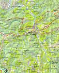
There are many walks and hikes that can be enjoyed in the vicinity of Greve. Details will be provided in the future, but in the meantime, please consult the map.
It is an easy and pleasant walk up to Montefioralle and so on a longer distance to Panzano.
Alternatively, one can walk north from Montefioralle via a deep valley and olive groves to the Romanesque church of San Cresci and then down-hill by a dirt road back to Greve. |
|

|

|

|
Monte San Michele Nature ParkGreve to Mount San Michele and back - minimum 6 - 7 hours.
From Karin Dietz, Panzano.
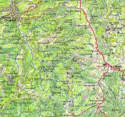
Here is a full day hike that I really like. The views are spectacular and the flora changes as you climb up towards the summit at 880 m. Leave your car in the car park (Greve map) in front of the "Palazzo della Torre" and the Casa del Popolo (good for a simple meal at the end of the day) and walk uphill towards the cemetery, following the signs to San Michele. Continue past Melazzano where the asphalt road changes into a dirt track (25 mins). At the turnoff to Lucolena (one hour, 630 m), you will see a large sign indicating the direction to San Michele. At this point, take the marked footpath 00 which you follow up to the Trattoria S. Michele (880 m). This takes about two and half hours all told, and in the tourist season the restaurant is open for food and drinks. From here on it is all down hill. Follow footpath 52 through the woods (marked by red spots on the trees) for about 45 minutes and then join the road. After another 45 minutes you reach the first intersection. Turn towards Lamole (not Volpaia) and in about 10 minutes you reach another intersection. There you take the road to Panzano (not Lamole) which you reach after 40 minutes. In Panzano, you might be able to catch a SITA bus to Greve. If not, head along the main Chiantigiana highway towards Greve for about 200 m and then turn left onto a dirt road, actually the old Chiantigiana, towards "La Valle" and Vitigliano. After half an hour you meet the modern Chiantigiana again and in another 20 minutes you will be Greve. |
|

|
|
|

|
|
|

|
|
|

|

|

|

|

|

|

|

|

|

|

|

|

|

|

|

|

|

|

|

|

|

|

|
|
